What is LiDAR Technology and How It’s Changing Mapping
What is LiDAR Technology and How It’s Changing Mapping.
Learn how LiDAR technology is revolutionizing mapping by providing precise 3D terrain data for industries like urban planning, forestry, and autonomous vehicles.
—
LiDAR, an acronym for Light Detection and Ranging, is transforming the world of mapping. By using laser pulses to create detailed 3D maps of landscapes, LiDAR is becoming indispensable in fields like autonomous driving, environmental monitoring, and urban planning. This technology has not only revolutionized traditional mapping but also opened doors to unprecedented applications.
—
What is LiDAR Technology?
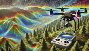
LiDAR technology uses laser pulses to measure distances between objects. Mounted on drones, airplanes, or vehicles, LiDAR sensors emit light pulses that bounce back when they hit an object. By calculating the time it takes for the light to return, LiDAR creates highly accurate 3D maps.
Components of LiDAR
1. Laser: Emits light pulses.
2. GPS Receiver: Ensures precise positioning.
3. Inertial Measurement Unit (IMU): Measures orientation and movement.
4. Data Processing Unit: Converts raw data into 3D visualizations.
—
How LiDAR Technology Works
1. Emission: The LiDAR system emits laser pulses toward the target area.
2. Reflection: The pulses bounce back after hitting objects like trees, buildings, or the ground.
3. Data Collection: Sensors record the time taken for light to return.
4. Data Processing: Advanced software converts the raw data into detailed 3D models.
READ ALSO: How VR Is Being Used in Training and Education.
—
Applications of LiDAR Technology in Mapping
1. Urban Planning
LiDAR helps create detailed city models for infrastructure planning and disaster management. It aids architects and engineers in designing resilient urban landscapes.
2. Autonomous Vehicles
Self-driving cars rely on LiDAR to navigate their surroundings. The technology provides real-time 3D maps, ensuring safe and efficient travel.
3. Environmental Monitoring
LiDAR maps forests, rivers, and coastlines to monitor changes caused by deforestation, erosion, or climate change.
4. Archaeology
Archaeologists use LiDAR to uncover ancient structures hidden beneath dense vegetation. For example, LiDAR revealed Mayan cities obscured by jungles.
5. Agriculture
Farmers use LiDAR to map fields, optimize irrigation, and analyze soil quality, boosting productivity.
6. Disaster Management
After natural disasters, LiDAR creates accurate damage assessments, helping authorities plan recovery efforts efficiently.
—
Benefits of LiDAR Technology
High Accuracy
LiDAR provides centimeter-level accuracy, making it ideal for precision mapping.
Speed
LiDAR systems scan large areas in a short time, reducing project timelines.
Versatility
From drones to handheld devices, LiDAR adapts to various platforms for diverse applications.
Detailed Data
The technology captures intricate details, including terrain elevation and object dimensions.
—
Challenges of LiDAR Technology
1. High Costs: LiDAR equipment and data processing are expensive, limiting accessibility.
2. Weather Dependence: Rain, fog, and dense vegetation can affect accuracy.
3. Data Overload: Managing and analyzing massive datasets requires robust computing power.
—
LiDAR in Action: Real-Life Examples
Google Maps
LiDAR technology powers Google Maps’ Street View feature, offering highly detailed visuals of streets and landmarks.
Forestry Management
Foresters use LiDAR to estimate tree heights and biomass, aiding sustainable logging practices.
Infrastructure Projects
LiDAR was crucial in constructing high-speed rail networks in Europe, ensuring precise alignments and safety measures.
—
Future of LiDAR Technology in Mapping
1. Miniaturization: Smaller, more affordable LiDAR sensors will make the technology accessible to a wider audience.
2. AI Integration: Artificial intelligence will enhance data analysis, unlocking new possibilities in mapping.
3. Space Exploration: LiDAR is being used in space missions to map planetary surfaces.
—
Conclusion
LiDAR technology is revolutionizing mapping by delivering unparalleled accuracy and speed. From urban planning to disaster management, its applications are endless. As the technology advances, its affordability and accessibility will drive innovation across industries, shaping a smarter, more connected world.