What is LiDAR Technology and How It’s Changing Mapping
What is LiDAR Technology and How It’s Changing Mapping.
Learn how LiDAR technology is revolutionizing mapping with laser precision. Discover its applications, benefits, and impact on industries like urban planning, forestry, and autonomous vehicles.
LiDAR, or Light Detection and Ranging, is a revolutionary technology transforming how we map and understand the world around us. By using lasers to measure distances and generate precise, three-dimensional information about the Earth’s surface, LiDAR has become a cornerstone of modern mapping and geographic analysis. From urban planning to environmental conservation, LiDAR is making its mark in a wide range of fields.
In this article, we’ll delve into what LiDAR is, how it works, its applications in mapping, and why it is reshaping industries worldwide.
—
What is LiDAR Technology?
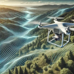
LiDAR is a remote sensing method that uses laser light to measure distances between a sensor and objects. It calculates these distances by timing how long it takes for light pulses to travel to an object and back. These measurements are then used to create detailed 3D maps of landscapes, structures, and even underwater terrains.
The main components of a LiDAR system include:
Laser Scanner: Emits the laser pulses.
GPS Receiver: Determines the exact location of the system.
Inertial Measurement Unit (IMU): Tracks the system’s orientation.
—
How Does LiDAR Work?
The basic process of LiDAR involves:
1. Emission of Laser Pulses: The LiDAR system emits rapid laser pulses.
2. Reflection of Pulses: These pulses bounce off objects in the environment and return to the sensor.
3. Time Measurement: The system measures the time taken for the pulse to return.
4. Distance Calculation: Using the speed of light, the system calculates the distance to the object.
5. Data Processing: Thousands of these measurements are combined to produce a detailed 3D map.
This level of precision is what makes LiDAR so effective in applications requiring high-resolution data.
READ ALSO: Top Smart Home Devices You Should Invest in This Year.
—
Key Applications of LiDAR in Mapping
LiDAR is playing a transformative role in mapping across various sectors:
1. Urban Planning
LiDAR is used to create accurate city models, aiding in infrastructure development, traffic management, and disaster preparedness. It provides detailed data on building heights, road networks, and open spaces.
2. Forestry and Environmental Conservation
LiDAR helps map forest canopies, assess biomass, and monitor deforestation. It can even penetrate dense vegetation to measure the ground surface, aiding in biodiversity studies and land conservation.
3. Archaeology
Archaeologists use LiDAR to uncover hidden structures beneath dense vegetation. For instance, it has been instrumental in mapping ancient Mayan cities buried in jungles.
4. Coastal Mapping
In coastal regions, LiDAR is used to measure shoreline changes, map underwater terrains, and monitor erosion.
5. Autonomous Vehicles
LiDAR is a crucial component of self-driving cars, helping them “see” their surroundings by creating real-time 3D maps for navigation and obstacle detection.
6. Disaster Management
LiDAR aids in assessing areas affected by natural disasters like floods, landslides, and earthquakes, providing critical data for recovery efforts.
—
Advantages of LiDAR Technology
LiDAR stands out due to its unique advantages:
High Accuracy: Provides detailed and precise data.
Versatility: Can map areas ranging from dense forests to urban centers.
Speed: Captures large amounts of data quickly.
Penetration Capability: Can see through vegetation to map ground surfaces.
Day and Night Operation: Works effectively regardless of lighting conditions.
—
Challenges and Limitations of LiDAR
Despite its numerous benefits, LiDAR is not without challenges:
1. Cost: High initial investment for equipment and data processing.
2. Weather Sensitivity: Performance can be affected by rain, fog, or snow.
3. Data Overload: Managing and analyzing large datasets requires advanced software and expertise.
—
How LiDAR is Revolutionizing Mapping
LiDAR’s impact on mapping is profound. Traditional mapping methods often relied on manual surveys and aerial photography, which were time-consuming and less accurate. LiDAR has changed the game by enabling:
3D Visualization: Allows for detailed visualization of terrain and structures.
Real-Time Updates: Facilitates rapid data collection and processing.
Integration with AI and Machine Learning: Enhances data analysis for predictive modeling and decision-making.
—
The Future of LiDAR Technology
As LiDAR becomes more affordable and accessible, its applications will continue to grow. Advancements in drone technology, combined with LiDAR, are expected to revolutionize industries like agriculture, construction, and environmental management. Furthermore, LiDAR’s integration with artificial intelligence promises to unlock new possibilities in automation and data analysis.
—
Conclusion
LiDAR technology is more than just a tool for mapping—it’s a transformative innovation reshaping how we interact with our environment. From city planning to environmental protection, LiDAR’s ability to provide precise, high-resolution data is empowering industries to make informed decisions and tackle global challenges.
As the technology evolves, its potential applications will only expand, cementing its place as a cornerstone of modern mapping and analysis.